top of page


ARCHAEOLOGICAL ILLUSTRATION
Like medical illustration for the field of medicine, archaeological illustration is for the academic publication of
found artifacts and sites.
I studied the production of artifact illustration, site plan mapping, and alteration of site photos for publication during my time at University College London under Fiona Griffin and Nadia Knudsen.


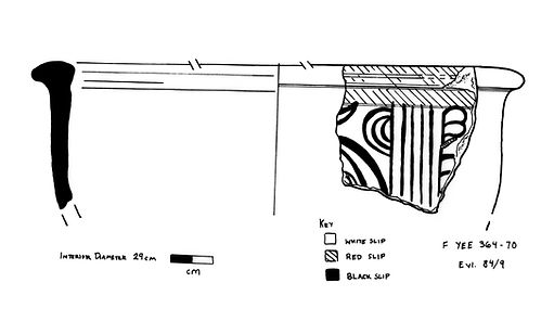


Graphic made in Photoshop utilizing images of Lekane sherds, from the British Museum and University College London's collections. Alterations made to put images in same color tone and to emphasize detail on discoloured outside of sherd (bottom left).
MAPS
Click image to enlarge

Map of Ancient Near East

Orignal Map
Map of Ancient Near East
1/2
The above map was created altering a map from Weaver, Scribes, and Kings: A New History of the Ancient Near East (2022). Alterations included expanding the map westward to include Greece and Lybia as well as a considerable amount south to include Nubia. Map alterations done using Photoshop.


The above map of Northwestern Campus made with google maps data and 1920 Sandborn maps. Created using Photoshop and Illustrator
GRAPHICS FOR PUBLICATION
This publication example piece was made in InDesign utilizing a paper I wrote for a course in Greek Art and Architecture at University College London.
Images were altered utilizing Photoshop and bottom trim detail created in Illustrator.
Original Loom Weight images from British Museum that were manipulated into transparencies in Photoshop


Page Border made in Illustrator
bottom of page